The Development of Warren Road – by Mary Butts
‘The Downs are very little used except for the, occasional donkey or goat’ — thus wrote the Earl of Onslow’s estate manager in 1887, and this may have been so for many years, in spite of the presence, from early times, of several farms in the area Tyting, Great Halfpenny and Warren Farms. Warren Farm is designated in the Victoria County History as ‘the old Manor House of Stoke in the chalk downs east of Guildford where the courts used to be held’, these were later moved nearer to Guildford as the site was too remote, but a plaster relief panel with motifs of a Tudor rose and fleur—de—lys in an upper room at Warren Farm lends credence to this claim. The whole area here was known as Browning’s Down and this was an alternative name for the farm house. Later, in the early 20th century, Mr. Smallpiece seems to have appropriated it for the name of his house facing Merrow Down which appears to have been used as the golf club house for some time.
An interview with Miss Frances White of One Tree Cottage produced some interesting information. Her grandfather drove his flock of sheep here from Wales and the land was then presumably used for grazing. In her father’s time the three farms, Warren, Lower Warren and Burwood, were worked conjointly, and in the 19th century were part of the Onslow estate. The land was probably used for the grazing of sheep and some cattle and in the Guildford Muniments Room is a document which mentions provision for the maintenance of a ‘game of conies’ on Merrow Down near Burwood Farm. The Warren and the Home Warren shown on the maps must have been places where the organised catching, or shooting of rabbits for ~’ood was practised.
‘An Account of the Succession to and Events which occurred in the Estates-of the Earl of Onslow’ written by George Onslow in 1870 to 1883 mentions the building of a row of cottages at the Warren Farm, presumably the three which face Pewley Down on a track opposite Burwood Barn. The same book has some interesting notes on Lewylsdene, then called Lewylsgrove, on the other side of Merrow Down. ‘The house at Lewylsdene…had been used as a keeper’s, house. It was got ready for letting (in1870)..’ the staircase was painted white and the windows facing the Downs boarded up. On the slopes of the hill adjoining there were kennels. The house was let to a Dr.Tristam, but in 1876 ‘in consequence of my marrying this year, I gave Dr.Tristam notice to quit Lewylsdene and my mother went to live there.’
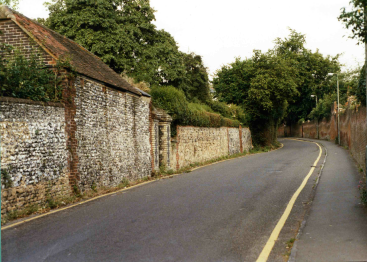
Two houses on One Tree Hill Road probably date from the 19th or early 20th century—St Martha’s Cottage, thought to be a former coach house, and St Martha’s a Lodge, further up the hill. Burwood Farmhouse on the other side was built in 1890. In the mid 19th century there were no houses on Warren Road beyond St Luke’s Hospital, then the Union Workhouse, and the lane running past it was called Union Lane. However, in a bill of sale of 1912, the land is described as being ‘ripe for building purposes.. for the erection of houses of good class’ and the humble Union Lane was re-christened Warren Road. The earliest house, Kingsherie, had been built at the top of the road in 1895. One Tree House on One Tree Corner was, put up by an artist, W .R .E .Spence in 1905, and was the only one, on the south side of the road for a long time. Mr Smallpeice was building Brownings Down at about this time, and some houses of about the same date were standing at the lower end of the road on the north side. By 1935 there were a number of houses along One Tree Hill Road of later date than One Tree Cottage. By this time too, the plots on what is now Downside Road ,had nearly all been sold and houses erected on the land which Miss White remembers as orchards and market gardens belonging to her family. A more recent development was the taking of more of the land originally belonging to Warren Farm for the construction of Little Warren Close. One Tree Hill Road however, is still a country road leading to Halfpenny Lane and the pond in the hollow, marked on the old maps and part of Tyting Farm, thence uphill to St Martha’s, with Great Halfpenny Farm and the manor of Chillworth beyond. The transverse track from the Pilgrims’ Way still leads up to Pewley Down and Lower Warren Farm stands in the valley below it.
By the 1970’s the large houses built, in the 20’s and 30’s on the north side of Warren Road were sold and the land used for building flats, and this has continued between Albury Road and Tangier Road. Cross Lanes, once an important route linking the London Road to Pewley Down, has shrunk for most of its distance to a footpath between houses. On the south side of the road the large houses remain, with others, in some cases, built on former garden land between them.
The original ‘one tree’ —a magnificent elm— standing on the triangle at the top of the road which gives on – to Merrow Down was cut down in 1972 and a copper beech planted at the junction of three roads to replace it.
From a field Called ‘Cowhide’ to the Austen/Sydney Road Triangle – by J A Cowie
 It is said that curiosity killed the cat and I’ve often wondered how it came about.
When we came to live in Austen Road, Guildford we were told that the house had been a farmhouse. This aroused a mild curiosity and a desire to disprove it, because I had been brought up in farming country and this did not have the right feel. But little did I guess how many avenues I would have to explore in doing so.
Obviously the first thing was to find the real farmhouse. (When I say ‘find’ I mean with the invaluable help of Shirley Corke in the Muniment Room at Castle Arch, without whose interest and encouragement I would never have progressed beyond the first clue.)
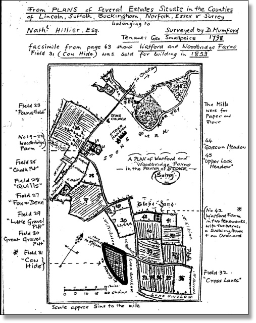
The Farm was quite easily found. It turned up in a book of ‘Plans of Several Estates’. In this a whole page is devoted to a plan of Watford & Woodbridge Farms in 1789. If you look at the accompanying plan you can see where the two farmhouses were and notice that the field called ‘Cowhide’ is the exact shape of Austen/Sydney Rd. area between Warren Rd. (then Albury Rd.) and Epsom Rd. (then Merrow Rd.). What is even more satisfying is that Watford Farm is still there at the end of Watford Close, off Cranley Rd. I was fortunate enough to find Mr Marshall, a builder who had lived in the house and had converted it into flats; he showed me where the original internal structure is still evident.
I should have been satisfied, but the names of the fields intrigued me — Quills, Fox and Denn, Crosslanes, Great Gravel Pitt, and of course Cowhide. I wondered how long these names had existed so I traced them back to a lease of 1785 and forward to the Stoke Tithe Map of 1840 matching names and acreages with great satisfaction; Cowhide was always around 10 acres.
However the next inevitable question was – when were the houses built? Conveniently there is a plan of this very field divided into plots of varying sizes (see plan) dated 1853. I was able from our early deeds to relate plots 15 to 19 to the area on which this semi-detached house was built, and again that should have satisfied me. But again I was intrigued by the occupations of the buyers of the plots. I had had the idea that this was when ‘the Merchants Moved Out’ but now I realised that this did not fit since these were butchers and bakers and cowmen and Plumbers, except for an occasional builder. In addition to this I discovered that the plots were not built on for years; on a large-scale map of 1871 only 10 houses had been built, out of the present 40. Ours, built in 1865 was one of the first. However many plots showed paths laid out and trees planted.
 So, I went back to the list of buyers and discovered that the seal opposite most of the signatures was that of the National Freehold Land Society. On advice I wrote to the Abbey National who kindly lent me their study of the Building Society Movement 1849 to 1949 by Sir Harold Bellman. The book is entitled ‘Bricks and Mortals’, but I misread this, as written down for me, as ‘Brides and Mortals’. Who was I to query the whimsy of the Building Societies? After all they advertise, with pictures of roofs over blushing brides, don’t they? No doubt there was some amusement at Abbey National Headquarters! The book is fascinating. It gives in full the speech of Richard Cobden at the Inaugural Meeting of the National Freehold Land Society, held at the London Tavern on 26th November 1849.
It was to – “help individuals, by means of small monthly contributions, to accumulate a fund by which they should be enabled, in the best and cheapest way, to possess themselves of the county franchise”.
This opened up an entirely new aspect to me, and I read on to discover that only one in sixteen of the male population of Surrey at this time could qualify for a vote. So, our little portioned out field was part of a movement to give the workman, the artisan and the small shopkeeper a voice in the government of the country. Cobden further made the point that owning land was a good investment because- “though the foreigner might, send a sack of wheat here (ref. to the Corn Laws)he could not send his garden ground.” However small the Plot it gave you a Vote!
After all this, it seemed imperative to establish when the houses were built, and what sort of people occupied them. Houses were not listed in streets in the Almanacs, until 1868 and, even after that, only by name and position on a list. Here the large scale map (40ft to the inch) was a great help because some of the houses have kept their name and I was gradually able to fill in the spaces between.
But it was still a puzzle that only half the houses had been built by 1871 which was 18 years after the purchase of the plots. But it then transpired that this was not necessarily completed for 10 years after signing although the land was laid out in gardens and probably rented. In fact the plot was still the vote until the Parliamentary Reform Act of 1867, when owning land was no longer necessary for enfranchisement. The building done before that date was probably by builders who owned plots and had other land. We should pay a tribute to names like Swayne, Loe, Mills and Smith whose houses are still standing today. It is sad that the centre space was never developed as an ornamental enclosure.
 So now we are concerned with a new group of people who either built houses or rented those already built. Fortunately at this point a neighbour, who is a genealogist, became interested in the project and copied out the Census Returns for the area for 1871. Already I had become familiar with the names attached to each house, but now each dwelling became peopled with families around whom we were able to build up quite a history. Christopher Hicks who lived in ‘our part of Mount View was an attorney and solicitor, born in Shrewsbury. He had a wife and 4 children and a servant called Mary Anne Sparrow who must have climbed to bed through a trapdoor and shared the space with the cistern; we hope she was small as her name suggests! Yet, across the road lived Joseph Marchant, a gardener, with his wife Harriet a laundress, and 6 children who had been born, in Crayford, Send, Stoke Worplesdon, Holy Trinity — so they must have moved around! So once more I was wrong in thinking that The Merchants Had Moved Out.
